Geospatial Technology for State Election
Karnataka Election Information System a.k.a KEIS is a first of its kind spatial solution designed and developed by KSRSAC for Chief Electoral Office of Karnataka to spread awareness and to provide enhanced services to the citizens of Karnataka and thereby improving the voter turnout in the state by providing details like location of polling station and its facilities, navigation aids to booth and nearest facilities of importance, details of constituencies / contestants etc.
Due to affordability of the smartphone and the technology advancements integrated GPS, GIS and visualization techniques the planning, monitoring and decision making has improved. Chunavana, the mobile app developed as part of KEIS is an example of how these technologies were extensively and effectively used by all stakeholders (officers, government, enforcement agencies, political parties, contestants etc) in carrying out mapping, progress monitoring, decision making and providing the enhanced citizen services. For the citizens, it's the information hub on its fingers. KEIS and Chunavana is a big hit amongst the voter population in the state. Thanks to the popularity drive taken by CEO, Karnataka and the extensive media coverage which helped to spread the information very efficiently in the state.
In continuation to the successful utilization in the 2018 assembly elections of the state, the KEIS and Chunavana have updated itself with details relevant to Parliament Election 2019 of the state.Currently chunavana helps the physically handicapped and senior citizens to book for the wheel chairs and pickup facility from the residence to cast their vote, the fundamental right.
Bringing state's election data is challenging; mapping of polling station and its boundary took less than 3 months with scientist of KSRSAC and officials on election duty in a well planned, coordinated and systematic manner, initially. The same was verified and updated in less than 2 weeks.
Why do we need Geo-Spatial Technology for Election?
As per the census 2011, state has 34434169-male and 33687691-female population. W.r.t 68236674-total population, among this, the electoral population count is around 73.00%, which is very significant! To provide awareness and information to this much mass audience, the only possible way is through information technology and spatial technology; it facilitates citizens to check information on their finger tip, through colorful, vibrant, pleasant maps. Some of the challenges, which can be easily solved by the geospatial technology, are
Visibility to Redistricting: GIS simplifies the redistricting process by offering a clear view of all possible variations in the electoral map.
Streamline Election Management: Election officers must work together to ensure polls run efficiently and coordinate a wide range of factors, like inspecting polling places, providing for central processing unit, enabling monitoring process to provide enhanced facilities to voters,managing the emergency facilities and alternate plans, citizen communication etc.
Encourage Voter Participation: Government and nonprofit organizations attract more people to the polls by informing situation of polling booth: Queue length.
Conventional System | Smart Spatial System | 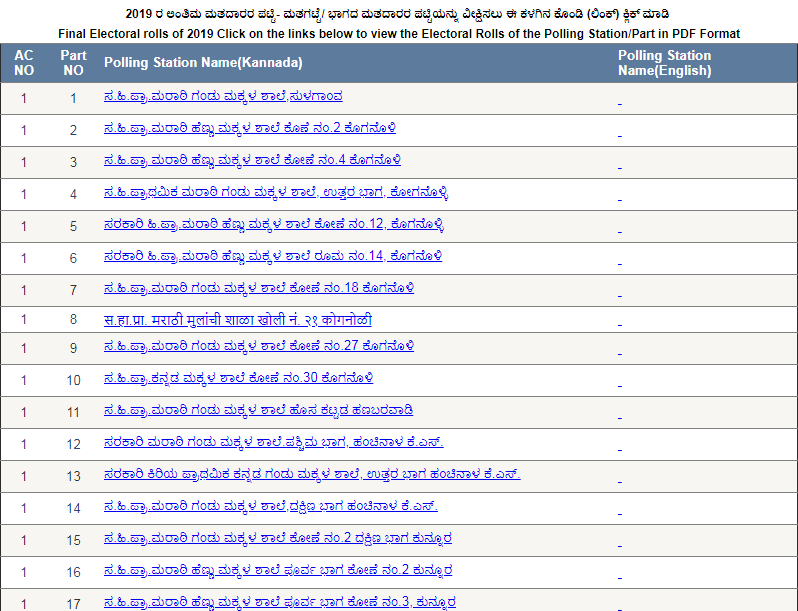 | 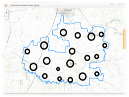 | | | | |
| |
| |
Statistics and Electoral Facts
Total number of Parliament Constituencies- 28 (21GEN, 5SC, 2ST)
Assembly Constituencies-224 (173GEN, 36SC, 15ST)
No of polling booth- 58,186
More details on statistics / Trends GIS visualization etc can be seen in https://kgis.ksrsac.in/election/
The application was also tested and approved for all security features from the empaneled list of web security audit agencies and is hosted in the Karnataka State Data Center, located in Bengaluru
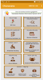
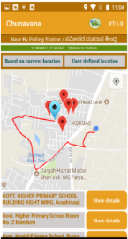
Chunavana Mobile Application
The Chunavana Mobile application is a citizen centric app, which is extensively used by citizens and got lot of appreciation from users across the state for the richness in content, correctness and real-time availability of information.More than 2,00,000 users installed from Android Play store and iOS App store, till date. The number of active users has doubled in the month of Feb 2019. More than 25,000 user hits were recorded from Feb 2019 onwards, till 5th March 2019.
Highlights
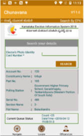
1.Finding the polling station, constituency details and route navigation by just entering the EPIC number.
2.Facility to book for wheel chair for senior citizen and physical challenged voters
3.The constituency wise voter-turnout was published in real-time for all urban stations and on periodical intervals of once in 2 hours
4.Live vote count was published in the mobile application
5.Contact details of all officers, details of contestants (name, photo, party, symbol, age and qualification etc).
6.Facility to locate nearest emergency services
7.Archival data of previous election
8.Various demographics and election based thematic maps
9.Citizen Feedback form on facilities provided at polling both
KPSIS: Mobile and Web Application - For Officers of Election Commission
Karnataka Polling Station Information System (KPSIS) is an mobile application developed specifically for capturing the photographs of polling booth room, buildings, infrastructure facilities and other associated attributes of every polling station that are needed for planning and decision making. It has various functionalities to monitor the progress, visualize/verify and approve the collected data through an workflow based systems. Progress monitoring was done by officers at different levels of hierarchy to monitor the progress and collate information of need.
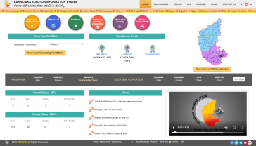
KEIS - The Web Application
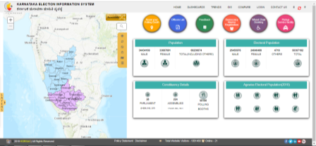
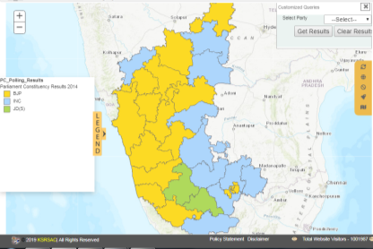
The web application developed by keeping the conventional and advance mechanism of data analysis; means both map and statistical representation has been maintained. The web version of the application has lots of value added information, statistics of voters, population, EP ratio, details and statistics of past assembly election, trends of assembly election, registrations for Wheelchair and pickup and drop facility on election day, to register as a Democracy Warrior etc. along with all facilities / functionalities available in mobile version (Chunavana). All the statistics and analysis are coupled with GIS based visualization. The GIS visualization of many statistics has flexible and user friendly operations like visualizing the data from district level to booth level, Option to compare the results and related data of last 2 elections. Apart, the option to visualize the results of elections is also available. Some of the GIS visualization of statistics and data include
1.GIS Map and query / visualization for Pooling station, booth boundary, constituency boundary
2.Comparative view on voter turnout, constituency wise winner / runner and margin, EP ratio
3.Booth wise, candidate wise number of votes of past elections.
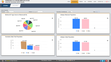
4.Demographic data like male and female electoral population, age wise electoral population (Age Group: 18-19, 20-29, 30-39, 50-59, 70-79, >80), male and female electoral population ratio
The application developed on bilingual mode (Kannada and English)
In KEIS, The web/mobile applications has very content which are authenticated and updated. Hence, it has becomes more popular and stable in the market.The application developed has highly rich with thematic geospatial contents of various parameters.The information on Karnataka election (past & present) and relevant information are visualized in the GIS environment to empower the citizens and promote transparency in the democracy.
|  |  |
| Home Page | GIS Themes |
| |  |
| Map showing Electoral Population (Like this, age wise electoral population, electoral population ratio many more can be generated) 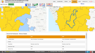 | Spatial Analysis 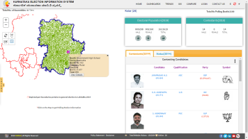 |
| Comparative Analysis | Constituency Details |
|  | 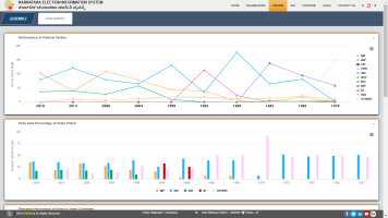 |
| Election Statistics | Analysis of trends over Elections |
 Adobe Acrobat Reader (External website that opens in a new window)
  Word Viewer (in any version till 2003) - External website that opens in a new window
 Excel Viewer 2003 (in any version till 2003) - External website that opens in a new window
 PowerPoint Viewer 2003 (in any version till 2003) - External website that opens in a new window
 Adobe Flash Player (External website that opens in a new window)
  Windows Media Player (External website that opens in a new window)